Yuanyang County is located in Honghe Prefecture, in the southeast of Yunnan Province. It is well known for its spectacular rice-paddy terracing. It covers an area of 2200 square kilometres and has a population of approximately 365,000 (2002), of which 88% belong to ethnic minorities and 95% is associated with agriculture.
The majority of the inhabitants of the county are from the Hani ethnic group. The administrative seat of the county is the town of Nansha (a.k.a. New Yuanyang) down in the Red River valley at an elevation of 240 meters. It is situated 12 km towards the north-east of the former administrative seat Xinjie (a.k.a. Old Yuanyang or just Yuanyang) to which it is connected by a 27 km long twisting mountain road. To the south of Old Yuanyang, the town of Panzhihua is positioned near the top of another major valley of rice-terraces. There are a total of 928 settlements in Yuanyang county, 826 of them being inhabited by only one single ethnic group.

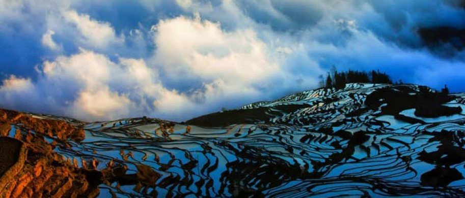
The town of Old Yuanyang is a Hani minority settlement atop a ridge of the Ailao mountain range at an elevation of around 1570 metres. It is a popular destination with photographers due to the vast areas of nearby mountains which have been cultivated into terraced rice paddies for at least the past 1300 years by the Hani people. Despite the overwhelming scenic beauty of its landscape and colourful local minorities, mass tourism hasn't developed in this region, mainly due to its remote location, lack of a nearby airport, and until fairly recent, relative inaccessibility due to bad road conditions.

The terraced areas of interest to visitors are mainly found between 1000 and 2000 metres above sea level. The winter temperatures here, although never freezing, are such that they only support one rice crop a year. After the harvest, from mid-September till mid-November depending on the elevation, the terraces are filled with water until April, when planting begins.

The vast majority of the ethnic minority women in Yuanyang county still wear traditional clothes as their daily attire. The main ethnic group is the Hani who share the region with several other minorities such as the Yi and Miao. Market days in the villages tend to be very colourful when the different minority groups in the vicinity, each in their own traditional costume, come together to trade and socialise.
In 2008, the State Administration of Cultural Heritage of the People's Republic of China submitted the Honghe Hani Terraced Fields for World Heritage Site status. A quote from the justification: Hani people have created fantastic and perfect land art of vast terraced fields in the heritage site. Integrating the terraced fields into the unique landform, forests and plant covers, valleys and streams and other natural landscapes they have developed a unique masterpiece of ethnic art which has organically fused the ethnical art, landscape art and agricultural techniques.
Visiting the Yuanyang Rice Terraces
With a subtropical climate, a visit to Yuanyang Rice Terraces is possible anytime during the year, a visit from November to April though will allow you to see the terraced fields filled with water which is the most beautiful scenery due to the multicolored reflections of sky and sun. Due to the huge surface of water the risk of fog is also quite high at that time.
The easiest way to get to the Yuanyang Rice Terraces is by car. But there are also busses leaving Kunming's southern Bus station to the town of Xinjiezhen (about 7 hours). Buses also arrive in Xinjiezhen from Gejiu (5 hours) and Jianshui (4 hours).
Once there, please take care while walking around. The steep paths in between the rice terraces can be quite slippery. Bring appropriate equipment.
Catch a sunrise or sunset over the terraces filled with water. This is one of the greatest highlights of every trip to China. The ideal spots to view the terraces at different times of the day are:
Duoyishu for sunrise (about 1hour ride from Xinjiezhen; 15minutes form Qingkou Visitor Center)
Laohuzui & Bada (each about 1hour ride from Xinjiezhen; 15minutes form Qingkou Visitor Center) and Longshuba for sunset (Longshuba is only accessible by foot in around 40 minutes from Xinjiezhen).
Geography

Yuanyang county lies at an altitude ranging from 140 along the Red River up to nearly 3000 metres above sea level in the Ailao mountains and is situated about 50 km north of the border with Vietnam.
The climate of Yuanyang county is mainly central sub-tropical monsoon with wet summers and dry winters. Average temperatures range from 26 Celsius down in the Red river valley to 4 Celsius in the upper reaches of the mountains.

The closest large towns to the west of Yuanyang county are Shiping and Yuanjiang. Gejiu is the major town to the north-east and also the capital of Honghe prefecture. 70 Km directly to the north of Yuanyang lies Jianshui, a small city with interesting monuments. A few hours to the south-east of Yuanyang is Luchun, another major Hani minority settlement turned modern city.
Due to recent highway construction, Old Yuanyang can now be reached in about 7 hours by direct bus from Yunnan's capital Kunming, situated 300 km to the north of the county, a trip which only a few years ago, would take 10 hours or more. Buses also connect Yuanyang with the town of Hekou and the border crossing with Vietnam (6 hours).

Ethnic groups
Vertical distribution of the various ethnic minority groups:
The Hani and Yi, the creators of the monumental rice terraced mountains which have made Yuanyang famous, are the original inhabitants of these regions. Both their languages belong to the Tibeto-Burman group. Their villages can mainly be found between 1300 to 1600 metres above sea level. The Dai moved here 700 years ago. The Zhuang 400 years ago. Both their languages belong to the Kradai language group. Their villages are situated in the warmer areas below 700 metres elevation, near and along the rivers. Their main crop is rice grow in paddy fields. The Miao and Yao (of the Hmong-Mien language group) are fairly recent arrivals to the region, only settling here 200 and 270 years ago. Their villages are in the cooler and drier upland areas, between 1600 and 1800 metres above sea level, where they grow maize.
(wikipedia)
- 1742 reads